File:Spring in the Canadian Arctic.jpg

原始檔案 (3,800 × 4,600 像素,檔案大小:3.33 MB,MIME 類型:image/jpeg)
摘要
| 描述 |
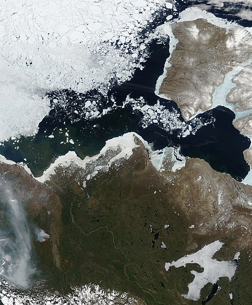
English: This image shows the western Canadian Arctic a few days after perpetual sunlight commenced for the entire region. The image captures the Arctic in a moment of transformation. Signs of winter are still present, but summer is clearly on the horizon. Sea ice in the Beaufort Sea has started to break up. A swath of open water, black in this image, separates the land from the dense pack of sea ice. Ice still fringes much of the land, but it is thinning. In many places, particularly around Banks Island, the land-bound sea ice is blue, pointing to thin ice or the presence of water on the ice.
Spring is beginning to touch land as well. While frozen lakes punctuate the landscape with white, many lakes are clear. The Mackenzie River flows ice-free to a broad partially frozen delta. Trapped behind a dam of ice, the muddy brown waters blur across the triangular delta. The water that is getting through the ice carries sediment into the Beaufort Sea, colouring the waters near the shore brown and green. With access to constant light, flowing water, and warmer temperatures, plants are beginning to grow. The land around the Mackenzie River has a deep green hue. The line between tundra and forest runs through this image. The forest is dark green, while the tundra is still brown. The land also shows the first sign of summer: large forest fires. One large forest fire is outlined in red. Smoke from nearby fires flows across the lower left corner of the image. The boreal forest needs fire to maintain the ecosystem, and large fires happen regularly in the summer. In the remote region shown here, lightning ignites most forest fires. |
| 日期 | |
| 來源 | NASA Earth Observatory |
| 作者 | Jeff Schmaltz |
Image captured by the Moderate Resolution Imaging Spectroradiometer (MODIS) on NASA’s Aqua satellite. Image courtesy of the MODIS Rapid Response Team at NASA GSFC.
授權條款
| 本作品由NASA創作,屬於公有領域。根據NASA的版權政策:“NASA的創作除非另有聲明否則不受版權保護。”(參見:Template:PD-USGov/zh,NASA版權政策或JPL圖像使用政策) | ||
 |
警告:
|
| 註解 | 該圖片含有註解:在維基媒體共享資源上查看註解 |
檔案歷史
點選日期/時間以檢視該時間的檔案版本。
| 日期/時間 | 縮圖 | 尺寸 | 使用者 | 備註 | |
|---|---|---|---|---|---|
| 目前 | 2010年6月16日 (三) 10:40 | | 3,800 × 4,600(3.33 MB) | Originalwana | {{Information |Description={{en|1=This image shows the western Canadian Arctic a few days after perpetual sunlight commenced for the entire region. The image captures the Arctic in a moment of transformation. Signs of winter |
檔案用途
下列頁面有用到此檔案:
全域檔案使用狀況
以下其他 wiki 使用了這個檔案:
- af.wikipedia.org 的使用狀況
- ckb.wikipedia.org 的使用狀況
- en.wikipedia.org 的使用狀況
- ms.wikipedia.org 的使用狀況
- sl.wikipedia.org 的使用狀況