File:Peloponnesian war alliances 431 BC.png
預覽大小:387 × 600 像素。 其他解析度:155 × 240 像素 | 482 × 747 像素。
原始檔案 (482 × 747 像素,檔案大小:37 KB,MIME 類型:image/png)
摘要

|
File:Guerre del Peloponneso 431aC mappa.svg是本檔案的向量版本。 如果品質不低,就應該優先使用該檔案,而非PNG檔案。
File:Peloponnesian war alliances 431 BC.png → File:Guerre del Peloponneso 431aC mappa.svg
更多資訊請參閱Help:SVG/zh。 |
 |
| 描述 |
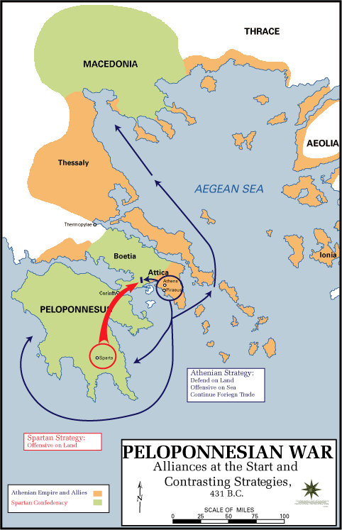
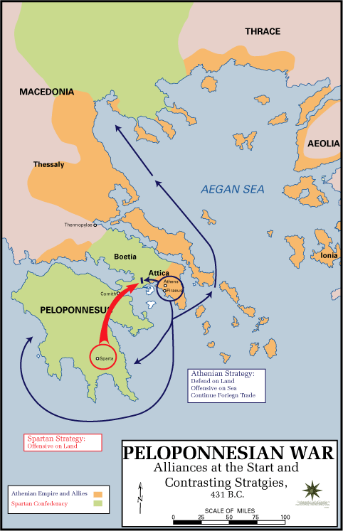
English: The Alliances of the Peloponnesian War |
| 日期 | 2009年五月5日 (原始上傳日期) |
| 來源 |
|
| 作者 | U.S. Army Cartographer, as amended by uploader to correct spelling mistake |
| 授權許可 (重用此檔案) |
Public domain as a work of the U.S. military.; amendments also released into the public domain |
| 其他版本 |
|
授權條款
此作品在美國屬於公有領域,因為其是由美國政府的官員或僱員,基於其個人公務目的製作的作品,參考美國法典第17篇第1章第105條。
注意︰本模板僅適用於美國聯邦政府的原創作品,不適用於任何美國州、屬地、聯邦個體、縣、市或任何次級政府的作品。本模板也不適用於1978年以後由美國郵政署出版的郵票圖案(參看美國版權局實踐綱領第313.6(C)(1)條)。也不適用於部分美國硬幣;參看美國鑄幣局使用條款。 |
 | |
| 此作品無已知的著作權限制,亦不受所有相關和鄰接的權利限制。 | ||
原始上傳日誌
The original description page was here. All following user names refer to en.wikipedia.
- 2009-05-05 11:43 The Anome 482×747× (34269 bytes) Fixed second spelling mistake, which had been accidentally reinstated by reverting to original source.
- 2009-05-05 11:28 The Anome 482×747× (34263 bytes) {{Information |Description = The Alliances of the Peloponnesian War |Source = http://www.faculty.umb.edu/gary_zabel/Courses/Phil%20281b/Maps/peloponnesian_war_alliances.gif |Date = |Author = U.S. Army Cartographer, as ame
檔案歷史
點選日期/時間以檢視該時間的檔案版本。
| 日期/時間 | 縮圖 | 尺寸 | 用戶 | 備註 | |
|---|---|---|---|---|---|
| 目前 | 2018年3月30日 (五) 19:35 | | 482 × 747(37 KB) | Trecătorul răcit | Gulf of Pella in the time, position of names |
| 2009年5月5日 (二) 12:03 |  | 482 × 747(33 KB) | File Upload Bot (Magnus Manske) | {{BotMoveToCommons|en.wikipedia|year={{subst:CURRENTYEAR}}|month={{subst:CURRENTMONTHNAME}}|day={{subst:CURRENTDAY}}}} {{Information |Description={{en|The Alliances of the Peloponnesian War}} |Source=Transferred from [http://en.wikipedia.org en.wikipedia |
檔案用途
下列頁面有用到此檔案:
全域檔案使用狀況
以下其他 wiki 使用了這個檔案:
- ar.wikipedia.org 的使用狀況
- br.wikipedia.org 的使用狀況
- ca.wikipedia.org 的使用狀況
- da.wikipedia.org 的使用狀況
- el.wikipedia.org 的使用狀況
- en.wikipedia.org 的使用狀況
- et.wikipedia.org 的使用狀況
- eu.wikipedia.org 的使用狀況
- fa.wikipedia.org 的使用狀況
- fi.wikipedia.org 的使用狀況
- fr.wikipedia.org 的使用狀況
- hyw.wikipedia.org 的使用狀況
- id.wikibooks.org 的使用狀況
- it.wikipedia.org 的使用狀況
- ka.wikipedia.org 的使用狀況
- ko.wikipedia.org 的使用狀況
- lv.wikipedia.org 的使用狀況
- ml.wikipedia.org 的使用狀況
- ro.wikipedia.org 的使用狀況
- ru.wikipedia.org 的使用狀況
- sh.wikipedia.org 的使用狀況
- sk.wikipedia.org 的使用狀況
- sq.wikipedia.org 的使用狀況
- sr.wikipedia.org 的使用狀況
- ta.wikipedia.org 的使用狀況
- th.wikipedia.org 的使用狀況
- tr.wikipedia.org 的使用狀況
- vi.wikipedia.org 的使用狀況
- xmf.wikipedia.org 的使用狀況
- yo.wikipedia.org 的使用狀況
- zh-yue.wikipedia.org 的使用狀況
- zh.wikipedia.org 的使用狀況