File:Lion distribution.png
預覽大小:687 × 600 像素。 其他解析度:275 × 240 像素 | 550 × 480 像素 | 880 × 768 像素。
原始檔案 (880 × 768 像素,檔案大小:51 KB,MIME 類型:image/png)

|
本圖片是以PNG、GIF或JPEG格式上傳。然而,其中包含的資料或訊息,應該重新建立成可縮放向量圖形(SVG)檔案,以更有效率或更準確的方式儲存。如有可能,請上傳本圖片的SVG格式版本。在上傳之後,請修改維基各姊妹計畫中所有使用舊版圖片的條目(列在圖像連結章節中),替換為新版圖片,並在舊圖片的描述頁中加入{{Vector version available|新圖片名稱.svg}}模板,同時移除本模板。
|
摘要
| 描述 |
Euskara: Lehoien banaketa: Berdez gaur egun, gorriz historikoki.
Suomi: Leijonan levinneisyys vanhalla ajalla.
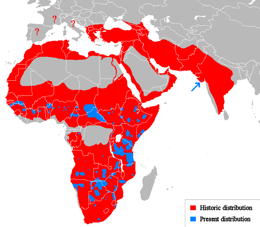
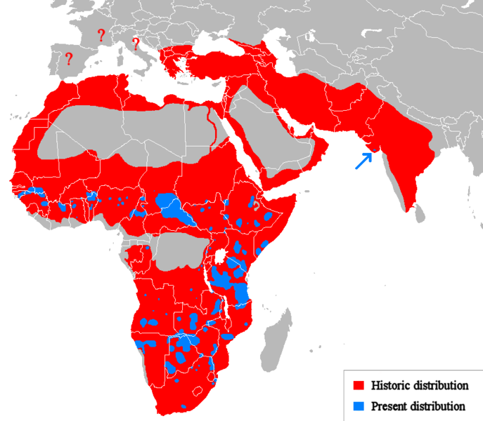
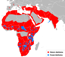
English: Geographical distribution of lions. Red (and blue) shows areas historically inhabited, blue shows areas currently inhabited.
Italiano: Areale storico (in rosso) ed attuale (in blu).
Русский: Ареал льва |
| 日期 | (UTC) |
| 來源 |
個人作品,使用:
|
| 作者 | Tommyknocker (talk) |
| 其他版本 | Derivative works of this file: Lion distribution-ar.png |
授權條款
| 此作品已由其作者,英文維基百科的Tommyknocker,釋出至公有領域。此授權條款在全世界均適用。 這可能在某些國家不合法,如果是的話: Tommyknocker授予任何人有權利使用此作品於任何用途,除受法律約束外,不受任何限制。 |
原始上傳日誌
Transferred from en.wikipedia to Commons by Egmontaz using CommonsHelper.
The original description page was here. All following user names refer to en.wikipedia.
- 2009-08-26 11:21 Tommyknocker 882×770× (42518 bytes) '
- 2009-08-24 21:02 Tommyknocker 882×770× (42434 bytes) {{Information |Description = |Source = I (~~~) created this work entirely by myself. |Date = ~~~~~ |Author = ~~~ |other_versions = }}
檔案歷史
點選日期/時間以檢視該時間的檔案版本。
| 日期/時間 | 縮圖 | 尺寸 | 用戶 | 備註 | |
|---|---|---|---|---|---|
| 目前 | 2018年3月22日 (四) 11:51 | | 880 × 768(51 KB) | Maphobbyist | Check |
| 2018年3月22日 (四) 11:23 |  | 880 × 768(51 KB) | Maphobbyist | South Sudan border | |
| 2012年5月15日 (二) 01:07 |  | 880 × 768(33 KB) | Ras67 | cropped, optimized | |
| 2010年4月19日 (一) 14:06 |  | 882 × 770(59 KB) | MPF | Change red/green to red/blue to avoid problems for viewers with red-green colourblindness | |
| 2010年1月11日 (一) 20:00 |  | 882 × 770(44 KB) | Tommyknocker | Distribution in Southern Europe during historical times controversial, therefore now represented with question marks. | |
| 2009年11月2日 (一) 17:01 |  | 882 × 770(42 KB) | File Upload Bot (Magnus Manske) | {{BotMoveToCommons|en.wikipedia|year={{subst:CURRENTYEAR}}|month={{subst:CURRENTMONTHNAME}}|day={{subst:CURRENTDAY}}}} {{Information |Description={{en|''no original description''}} |Source=Transferred from [http://en.wikipedia.org en.wikipedia]; transfer |
檔案用途
下列頁面有用到此檔案:
全域檔案使用狀況
以下其他 wiki 使用了這個檔案:
- ab.wikipedia.org 的使用狀況
- af.wikipedia.org 的使用狀況
- alt.wikipedia.org 的使用狀況
- am.wikipedia.org 的使用狀況
- ary.wikipedia.org 的使用狀況
- arz.wikipedia.org 的使用狀況
- ast.wikipedia.org 的使用狀況
- as.wikipedia.org 的使用狀況
- azb.wikipedia.org 的使用狀況
- ban.wikipedia.org 的使用狀況
- ba.wikipedia.org 的使用狀況
- bcl.wikipedia.org 的使用狀況
- be.wikipedia.org 的使用狀況
- bg.wikipedia.org 的使用狀況
- bh.wikipedia.org 的使用狀況
- bn.wikipedia.org 的使用狀況
- bs.wikipedia.org 的使用狀況
- ca.wikipedia.org 的使用狀況
- ca.wikiquote.org 的使用狀況
- ceb.wikipedia.org 的使用狀況
- ce.wikipedia.org 的使用狀況
- ckb.wikipedia.org 的使用狀況
- cs.wikipedia.org 的使用狀況
- de.wikipedia.org 的使用狀況
- de.wikibooks.org 的使用狀況
- diq.wikipedia.org 的使用狀況
- el.wikipedia.org 的使用狀況
- en.wikipedia.org 的使用狀況
- eo.wikipedia.org 的使用狀況
- eo.wiktionary.org 的使用狀況
- es.wikipedia.org 的使用狀況
- es.wikibooks.org 的使用狀況
- et.wikipedia.org 的使用狀況
- eu.wikipedia.org 的使用狀況
檢視此檔案的更多全域使用狀況。