File:STS066-89-69 - Image of Taiwan Northern Half.jpg

本预览的尺寸:600 × 600像素。 其他分辨率:240 × 240像素 | 480 × 480像素 | 768 × 768像素 | 1,024 × 1,024像素 | 2,048 × 2,048像素 | 5,294 × 5,294像素。
原始文件 (5,294 × 5,294像素,文件大小:5.68 MB,MIME类型:image/jpeg)
摘要
| 描述 |
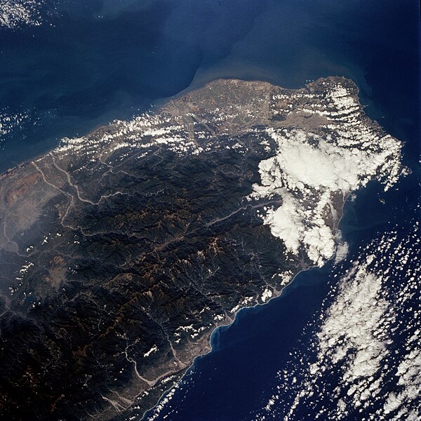
English: The island of Taiwan (National Republic of China) has a population of more than 21 million in an area the size of Switzerland; this photograph shows the northern half of the island. Most of the inhabitants live along the plains that extend along the entire west coast. Ti-pei, the capital with a population of almost 3 million, is located near the northern tip of the island. The small scale of the photograph and the gross resolution allow only identification of the general location of the urban area at the northern end of the island. Many short rivers that drain east and west arise in the Chungyang Mountains that extend for almost the entire length of the country. The mountains of Taiwan, with some of the central ranges rising to altitudes of more than 10 000 feet (3000 meters), are young and still actively undergoing tectonic movement. Taiwan is bordered on the west by the Taiwan Strait, which separates the country from mainland China (People Republic of China), and on the east by the Pacific Ocean. Taiwan is an amazing economic success story; along with Japan, Hong Kong, South Korea, and Singapore, it is considered to be one of the "Pacific Rim Economic Tigers." |
| 日期 | |
| 来源 | JSC Gateway to Astronaut Photography of Earth |
| 作者 | Earth Science and Remote Sensing Unit, 林顿·约翰逊太空中心 |
| Mission | STS066 |
| Roll | 89 |
| Frame | 69 |
| Geographic area | North Half of Taiwan |
| Features | Mountains, cities, rivers, haze |
| Cloud percentage | 30% |
| Altitude | 162 nautical miles (300 km) |
| Look angle | 25° |
| Look direction | NW |
| Sun Azimuth | 154° |
| Sun Elevation | 47° |
| Camera | Hasselblad |
| Film | 5046: Kodak, natural color positive, Lumiere 100/5046, ASA 100, standard base |
| Focal length | 100 |
| 相机位置 | | 在以下服务上查看本图像和附近其他图像: OpenStreetMap |
|---|
| 物体位置 | | 在以下服务上查看本图像和附近其他图像: OpenStreetMap |
|---|
本图像或视频收录于美国国家航空航天局 (NASA)休斯顿太空中心(Johnson Space Center),其照片编号是: STS066-89-69 此标签不表示文件的著作权状态。任何文件在附有此标签的同時还需要一个有效的著作权标签。请参阅许可协议说明页面以了解更多信息。 其他语言:
|
许可协议
| 本文件完全由NASA创作,在美国属于公有领域。根据NASA的版权方针,NASA的材料除非另有声明否则不受版权保护。(参见Template:PD-USGov/zh、NASA版权方针页面或JPL图片使用方针。) | ||
 |
警告:
|
文件历史
点击某个日期/时间查看对应时刻的文件。
| 日期/时间 | 缩略图 | 大小 | 用户 | 备注 | |
|---|---|---|---|---|---|
| 当前 | 2024年2月20日 (二) 10:58 | | 5,294 × 5,294(5.68 MB) | Askeuhd | Improved quality and resolution |
| 2004年11月15日 (一) 07:23 |  | 640 × 640(144 KB) | Wdshu | {{PD-USGov-NASA}} |
文件用途
以下页面使用本文件:
全域文件用途
以下其他wiki使用此文件:
- zh.wikinews.org上的用途